Previous research
The short version
In my Ph.D. work, I have focused on the effects of temporal resolution of a priori profiles on NO2 retrievals from the Ozone Monitoring Instrument (OMI). I found that using daily profiles, instead of monthly average profiles, can have a significant effect on the retrieved NO2, and that it is especially important in certain approaches to constrain emissions and lifetime of NOx from space (the paper). I designed a major upgrade to the Berkeley High Resolution OMI NO2 retrieval that incorporated daily profiles, and also took advantages of developments in the WRF-Chem model to include the effect of lightning on the NO2 profiles (the paper). Currently, I am using the new version of the retrieval to study how NOx emissions and chemistry changed over the continental US between 2005 and 2015.
The full story
My research focuses on the development and application of new NO2 retrievals for the Ozone Monitoring Instrument (OMI) on board the Aura satellite. Launched in 2004, OMI had the highest spatial resolution of any satellite capable of observing NO2 until the launch of TROPOMI (the Tropospheric Monitoring Instrument) in October 2017. OMI's spatial resolution is great enough to allow us to resolve gradients in NO2 column density between cities and the surrounding area. The ability to observe NO2 concentrations at this resolution provides a powerful tool to understand how NOx (the sum of NO and NO2) emissions and chemistry vary from city to city. At this resolution, the rate of loss of NOx as it is advected out of cities can be measured, which combined with knowledge of the wind speed, allows us to infer the rate of chemical loss. When that is combined with measurments of the total amount of NOx in an urban plume, the emissions rate can be inferred by a mass balance approach.
However, getting the most benefit out of satellite observations at this spatial resolution poses some unique challenges. Satellite observations of NO2 infer the amount of NO2 in the column extending vertically from the Earth's surface to the top of the troposphere by measuring the absorbance of sunlight passing through the atmosphere in a similar manner to any UV-vis spectrometry experiment. However, NO2 at different altitudes in the atmosphere affects the amount of outgoing reflected sunlight differently, and so the same physical amount of NO2 will register as a different measured amount depending on its altitude, unless that is taken into account. To do so requires the use of two models, a radiative transfer model (RTM) and chemical transport model (CTM). The latter simulates vertical distributions of NO2 for different locations around the world, and the former accounts for how that vertical distribution of NO2 affects the top-of-atmosphere radiances observed by the satellite.
CTMs are computationally expensive to run at high spatial resolution, so standard, worldwide retrievals of NO2 simulate the necessary vertical distributions at resolutions greater than 1° by 1°, which is about 10x coarser than a nadir OMI pixel. A number of groups have experimented with trading global coverage for better resolution of the NO2 profiles, and find that simulating NO2 profiles at comparable resolutions to OMI pixels increases NO2 retrieved over high emission areas, like cities and oil or gas extraction sands, by up to 100%. My research took the next step: if spatial resolution matters that much, what about temporal resolution? These retrievals often use monthly average profiles; how much difference does using daily profiles make?
My research found that the temporal resolution of the NO2 profiles does have an important effect on the retrieved NO2 column densities, especially when constraining emissions and lifetimes with those retrievals. I found that switching from monthly averaged to daily profiles would alter the retrieved NO2 column density by as much as 40%. Further, while averaging the satellite data over multiple months reduces the importance of daily profiles in most cases, I also found that in regions with significant lightning NOx emissions, the temporal resolution even affects a multi-month average. Daily profiles are especially important when constraining emissions and lifetime, because in that application, NO2 observations downwind of a source are chosen, rather than using all directions in a standard average, thus the day-to-day variation in wind direction becomes an important part of the NO2 profiles used in the retrieval process.

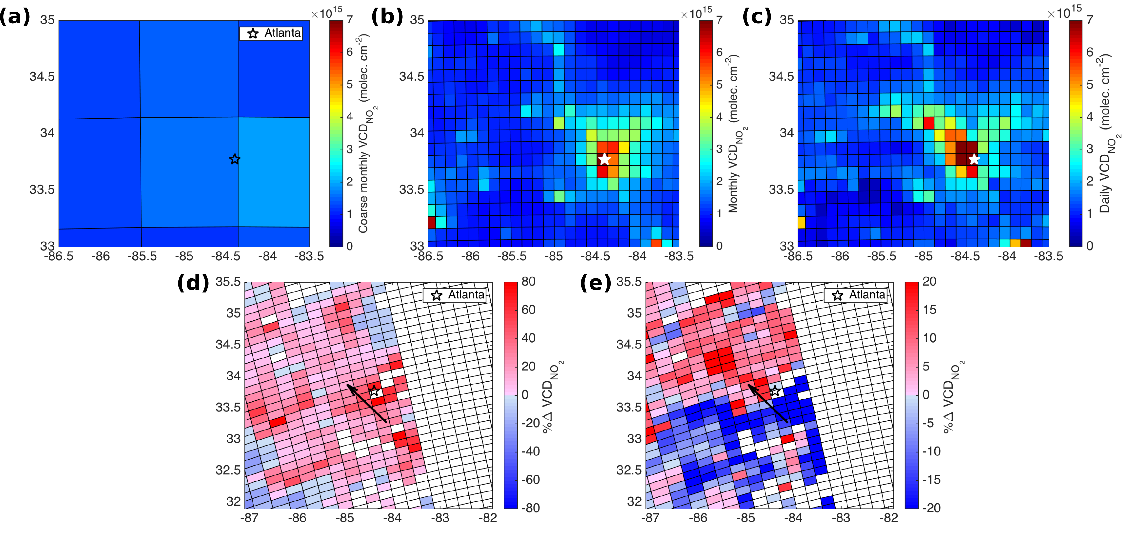
Figure 1: Top row - modeled NO2 VCDs around Atlanta, GA, USA representing three sets of a priori profiles for one day. (a) 108 km resolution, monthly average. (b) 12 km resolution, monthly average. (c) 12 km resolution, daily average. In this case, greater column density indicates greater surface NO2.
Bottom row - percent change in retrieved NO2 VCDs as when changing the a priori profiles from (d) 108 km to 12 km monthly, and (e) 12 km monthly to daily.
Increasing the spatial resolution of the a priori profiles (a to b) dramatically increases the retrieved VCDs right over Atlanta (d). Switching from monthly to daily a priori profiles (b to c) has a smaller effect on the retrieved VCDs (e), but there is a clear upwind/downwind difference. The wind direction is indicated by the arrow in (e).
This work led directly to the creation of a new version of the Berkeley High Resolution OMI NO2 retrieval that incorporated daily NO2 profiles, along with several other improvements. Now, I am using the upgraded retrieval to study how NOx emissions across the continental United States have changed between 2005 and 2015 and what effects that has had on NOx chemistry. The ability to probe changes in NOx chemistry from space offers a powerful method to predict how future emissions controls will affect the concentrations of related pollutants, such as ozone.